|
I left World
Wide Aerial Surveys and commenced with Adastra in April 1957 and
a month later I was officially operating as navigator. The first
aircraft I was slotted in as navigator was Adastra’s Avro Anson
VH-AGA based at the time in Essendon, Victoria. Later, Adastra
acquired another Anson, VH-BLF, and my first stint as navigator
with her was when she commenced operations in Sydney, NSW in April
1958. The navigational facilities were exactly the same but the
prime difference with the aircraft was that BLF had electric starter
motors and electric gear retract mechanism, the latter being easier
on the navigator. (See Wal Bowles’ story on Operating
the Avro Anson).
A typical day in operation was to get out to the airport if the
weather was satisfactory and select the camera to install for
the prime project on the list. The pilot would go to flight planning
and give the pertinent details of our ETD, transit to the survey
area, the height (above terrain) and size of the area, number
of runs, estimated time of operation there and ETA back at Essendon.
Whilst awaiting the pilot's return, the engineer would be attending
to his “daily”, the camera op would either mount or check his
specific camera and peripherals, and the navigator would re-check
his survey map details which he generally would have done earlier
that day or the previous night.
When the pilot returned and all was checked and ready for start-up,
the Anson's Cheetah engines required a crank wound inertia start
which at times could be time and energy taxing and the camera
op was sometimes required to assist in starting. Later this problem
was overcome by Bill Mitchell, an engineer of much resourcefulness!
(See Wal Bowles’ story Starting
the Anson for Bill’s starting method). Immediately after take-off,
the navigator (in the right hand seat) retracted the landing gear
with approximately 145 turns; OK if bright and alert, not as nice
if feeling a little seedy. He also pumped the flaps to specified
positions on the pilot's command when required.
When close to the survey area, the navigator would indicate to
the pilot the proposed area to start the project and after folding
his collapsible seat to starboard, would crawl into position in
the nose where he lay prostrate on his stomach. To facilitate
some degree of comfort, there was a foam mattress approximately
five inches thick and covered with a type of brown “duck” material.
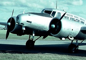
Anson
VH-BLF at Essendon in June 1960. (Photo: Kevin Pavlich)
The nose of the Anson incorporated several plastic “viewing” panels
crafted by the “Sheeties”. These were modest but appropriate for
what was required. These windows comprised a circular panel directly
ahead, a small panel on either side and another below the circular
panel, all of similar size. There was also a flat panel under
the nose ahead of the drift sight (all of these for forward viewing),
a panel either side of the nose, level with the navigators head
(for viewing the next flight line) and a couple of small circular
windows slightly behind and above these to provide light for map
reading.
The main instrument utilised for survey correction was the Aldis (Drift)
Sight compiled for operation with the Williamson Eagle IX camera.
In other words, if using a 6 inch lens with the Eagle IX, the
appropriate 6 inch sight was installed. The sight was situated
in front and close to the navigator with the top and middle section
available for manual correction with the base (and prism mirror)
exposed to the elements. The movable prism mirror was used to
look forward in various degrees from directly ahead to behind
the aircraft. Viewed when looking through the sight was a marked
square relative to the Eagle IX format with lines marked for time
interval and a feature that moved with ground speed from one specified
point to another. This was checked with a stop watch for a 60%
forward overlap plus marks at either side to adjust 25% sidelap.
There were also two (close) parallel lines running top to bottom
in the center where again a ground feature was traced to keep
between the lines to find and adjust port or starboard drift.
The result could be read from a scale graduated in degrees circling
the outside body at the top of the sight near the leveling adjustment.
The navigator passed on drift correction for the camera and time
interval correction (for forward overlap) for the intervalometer
on both the Williamson Eagle IX and OSC (Ordnance Survey Camera)
cameras. For all the Wild RC series cameras, the camera op had
built in facilities for these two applications and the navigator
(unless queried by the camera op) was relieved of this duty.
The Anson was used frequently for survey below 10,000 feet but
carried oxygen because quite a number of projects were flown up
to 16,000 feet (it took a while to get there!). The lowest photo
navigation survey (that I did) was 900 feet.
All the work that I as navigator was involved with in the Anson
was on a “center-line” basis, either using maps generally and
at odd times (mainly geophysical) photo mosaics prepared prior
to the survey. The map could have been compiled at the HO, but
often to take advantage of a new contract, it was compiled by
the navigator in the field after ascertaining the contract border
area and scale details so that after acquiring the specific map
that included the contract area, he would configure the height
to be flown for area coverage and mark in the center lines to
be flown that would incorporate the 25% sidelap.
Once in the area, the navigator would guide the pilot to a point
approximately 5-6 nautical miles from the start of the first line.
All flight lines (unless a tie line or a special contract) always
ran in an E-W or W-E direction. After initially giving the pilot
ever decreasing corrections to straddle the line, the navigator
would ascertain the correct drift and give the pilot a definite
heading, (say 266ş after applying 2ş of starboard drift). After
checking for forward overlap, he would pass the drift and time
interval on to the camera operator. It was always required for
any photo survey that at least two photos (or principal points
contained therein) should be outside the border of the area, and
if the navigator were happy with all at this stage he would give
the “CAMERA ON” command. If he were not sure that he had all the
details correct in time to start, he would advise the pilot and
camera op and ask the pilot to go around so that he could go through
the preliminary actions again to get the camera on and be operational.
Once established on line, he would continually monitor drift and
time interval and pass any corrections to the pilot or camera
op. Towards the end of the line he would look at the next line
so that he could memorise features of the terrain to make it easier
on the run up to it. After he was satisfied that he had completed
the line, he would give the command “CAMERA OFF”. He would still
go on a little further before telling the pilot to come around
to port (or starboard) to go through the prelims of starting the
next line. If the drift was fairly consistent, the camera op would
have a reciprocal drift to apply to the camera and the pilot would
have an idea of a reciprocal heading before commencing the next
line.
As the day continued, provided there were no problems with weather,
survey or aircraft equipment, the task became easier because of
application continuity. After a few lines, the pilot could get
very close to the heading of the new line after finishing the
previous line. Fuel endurance and shadow interference, (it was
unusual to survey prior to 9am or after 4pm), were also factors
to be taken into consideration when planning.
For the navigator it was very difficult after a couple of hours
of lying on the stomach with your elbows propped, moving maps
and adjusting the drift sight, craning your neck over the sight
and gazing through the different panels. Eventually it became
quite uncomfortable in what should have been a resting position.
Another factor that affected us all was the cold. In the Anson,
there were heaters, but after a time at the higher altitudes,
they lost their efficiency with the consequent crew discomfort
and loss of proficiency at their task. All the Geophysical survey
was flown in Anson VH-BLF. Contract AH138 was flown at 350 feet
and contracts AH139 and AH140 were flown at 500 feet. These were
all mineral contracts flown early in 1960. Geophysical survey
navigation was different in that most of the lines were marked
on photo mosaics and more latitude was given on straddling the
line. I navigated from the cockpit and approached the line as
in photo survey and still gave the “camera on” command to the
technician at the commencement of the line so he could switch
on the “trailing” camera that identified features to confirm that
we were indeed on line. Similarly, I gave a “camera off” command
on completion of the line.
Pilots who flew either VH-AGA or VH-BLF during my time with
Adastra.
|
Allen
Motteram
|
|
Bruce
Sellick
|
|
Max
Garroway
|
|
Bob
Love
|
|
Jack
Howard
|
|
Ken
Rowlands
|
|
Ted
McKenzie
|
|
Wal
Bowles
|
|
Keith
Cooper
|
|
George
Smee
|
Extra Curricular Activities Navigating in the Avro Anson.
| (a) |
September 1958. I mentioned the lowest photo survey being at 900 feet. This
was the first time that Adastra was contracted to photo survey
Bunnerong Power Station (Sydney) coal storage. (Previously,
ground surveyors scrambled around the coal heaps for weeks
with their trusty theodolites). It was only one run but we
went around a few times as we were using the Eagle IX (I think,
but can’t confirm) with a 10 inch lens and the time interval
(with wheels and flaps down eventually) was very short and
hard to consistently confirm. We flew on two days, one each
in both AGA and BLF and when finally completed, the crew spent
quite some time unfurrowing their knitted brows. |
| (b) |
January
1959. We were based at Mt. Gambier surveying for Vic. Irrigation
and S.A Drainage Govt. Depts. The heat at the time was pretty
fierce and on the 17th the local fire people (through DCA)
asked if we would spot for a fire burning in a large pine
forest plantation near the airport. We agreed and flew up
parallel to and on the western long side of the rectangular
shaped forest. We were a little above the canopy to spot
the extent of fire damage and suddenly noticed that we were
losing height. Obviously we were not prepared for the effect
of intense heat on the flying capabilities of the Anson in
hot air. The pilot immediately applied full power and started
to ease away to the west. We were still getting dangerously
close to the ground and it was only when we fortunately passed
the northern boundary of the inferno that the cooler air enabled
the aircraft to climb. When we landed, another effect of the
heat was evident when our landing gear tyres started to roll
up the soft tar in the macadam of the dispersal area. Five
forest fire workers lost their lives in the area at the time.
|
| (c) |
January
1962. It was early morning (7am) on Tuesday 23rd January at
Tullamarine (the suburb, the airport wasn’t on the planning
board then) close to Essendon where our family was renting
because of being based in Melbourne. Two senior gentlemen
whom we dealt with from Victoria Lands Department unexpectedly
(we always visited them!) knocked on our front door to speak
with me. The huge fire that had swept through the Dandenong
Ranges over the previous few days had finally been extinguished.
What these gentlemen required was for us to start covering
the whole bushfire area ASAP and it didn’t matter whether
it was under cloud or not. They had been in touch with Adastra
prior to this and were waiting for the fires to finish before
they approached us. They had even prepared the flight maps
with the lines marked to cover the fire areas and mentioned
that they would prefer that we kept the operation to ourselves
for the next week. The camera used was the Eagle IX (6 inch
1/100 @ f11) and the height was 9400 feet. We were in the
air later in the morning and flew 14 runs in the Kinglake/Ringwood
area and were aloft for 3hrs 40mins. We were in the air again
later in the day flying 7 runs in the Dandenongs bushfire
area taking 2hrs 5mins. We flew again on the 26th and could
only get two runs in the Healsville bushfire area taking 1hr
35mins (not quite sure what held us up). Our final flight
to complete the contract was on Jan. 30th when we flew 11
runs in the Healsville bushfire area. I have purposely left
names out of this story for obvious reasons. When I approached
one of these gentlemen in mid February on the subject of what
it was all about, he said the best way to answer my question
was to initially ask if I knew that the Victorian State Govt.
was financially assisting people who had suffered hardship
because of the fires. In response to my affirmative answer,
he then said that two days previously he was personally interviewing
people who applied for assistance. One chap had told him the
story about having to run clear of the fire in his paddock
leaving his tractor which the fire soon completely destroyed.
He asked the chap to point out on a large council map including
his property where it actually occurred. The chap did this,
so my contact then produced a photograph of the chap's home
with the tractor unscathed near a shed and asked if he wanted
the photo enlarged to recognise his tractor. The chap apparently
answered no as he recognized it. He was rather embarrassed
to learn then that the photo was taken after the fires had
finished! I don’t know how much money was saved, but I certainly
understood the reason for the contract. |
| (d) |
June
1962. Possibly forgotten now because of the time factor, but
in 1962 there was quite a scare about the Sirex Wasp being
imported unnoticed in timber shipments. Given a chance of
large infestation of our timber reserves, it could devastate
the industry. The job was to arrest it ASAP and I hope Adastra
in some way helped to achieve this. It was in VH-AGA using
an Eagle IX with 6 inch lens, but we used two types of Kodak
Ektachrome, High Contrast and Camouflage Detection. There
were two areas (Dandenong and Ringwood) with four runs on
each to be flown at 3960 feet and 7920 feet with both films.
We heard that a successful result was achieved. The scare
apparently ceased, as we didn’t hear about the Sirex Wasp
again. I have often wondered how much Adastra’s work contributed.
|
| (e) |
Because
I can’t find it in my log book, I am not sure when, but we
were based in Melbourne when at one time because of a mapping
query it was decided to see how high the Anson could operate.
We got to just over 19,500 feet and she was hanging on her
props. That was enough for us so we returned to earth. |
Kevin Pavlich
19th October 2004
|