|
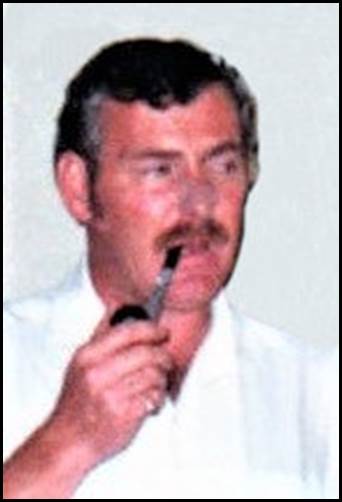
Jock
Head was born on 14 August 1946. He had worked as a commercial
pilot for Adastra Aerial Surveys in the early part of the 1970s
prior to coming to National Mapping in 1980.
Adastra Aerial Surveys had its beginning in 1930 when former World
War I Australian Flying Corps pilots Frank William Follett (1892-1950)
and Henry Talbot (Bunny) Hammond (1895-1982) formed the Adastra
Flying School in Sydney. On 18 August 1930 the family company
Adastra Airways Ltd was registered. There were 7 subscribers to
the companys initial £3 000 capital that was raised through the
issue of £1 shares. These subscribers were Frank Follett, his
wife Helen Gertrude Follett (née Molloy) and two of Franks sisters:
Evelyn Mary (Pinkie) Follett (1902-1977) and Beatrice Hilda (Bee)
Follett (1897-1978). Bunny Hammond and his wife Madge were also
subscribers as was a Mrs Sadie Ann Youngson (née Mackieson).
Some time later Bunny Hammond moved on to other pursuits and later
joined the Royal Australian Air Force until discharged in 1945
with the rank of Group Captain and the award of Officer of the
Order of the British Empire. Hammond returned to Adastra as General
Manager after Folletts death in 1950.
In 1935 Adastra acquired a Williamson Eagle IV aerial survey camera
and commenced undertaking aerial photography acquisition contracts.
Over the next 4 decades it became a multi-faceted aerial survey
company involved in aircraft operation, geophysical surveys, airborne
terrain profiling, aerial photography, photogrammetry, aerial
photography mosaics, reprographics, photo laboratory, and ground
control surveys. The company began to decline in the early 1970s
and ceased operating in 1976.
From his mid-20s to his early 30s Jock Head flew various aircraft
for Adastra between 1970 and 1976 when the company ceased to operate.
At Adastra Jock flew Cessna 185, Cessna 206, Cessna 320, and Aero
Commander 500 (Shrike) aircraft.
At age 34 years, Jock joined the National Mapping Aviation Section
as a staff pilot on 7 August 1980. His appointment to the nominal
position of Technical Assistant Grade 1 was promulgated on page
50 of the Commonwealth of Australia Gazette , Issue P 10, on 30
September 1981. The Aviation Section was based at Nat Maps Ellery
House office at 280 Thomas Street Dandenong. Initially Jock worked
under the direction of Terrence Gerald (Terry) Mulholland (1935-2013)
who was Nat Maps Chief Pilot between early 1978 and October 1988.
Other pilots in the Section when Jock joined were Harry William
(Harry) Baker (who joined on 28 March 1978) and Peter Prior (who
joined in May 1978).
During his 12 years as a staff pilot with Nat Map, Jock flew the
following Nat Map aircraft:
Nomad N22B-25 (VH-DNM) that was used between July 1976 and September
1982 for aerial photography (with a Wild RC9 aerial survey camera)
and for laser terrain profiling operations. ·
Cessna 170A (VH-CAS) that was used between February 1978 and December
1982 for map inspection and spot photography operations. ·
Cessna 421C Golden Eagle (VH-DRB) that was used between August
1982 and July 1995. This aircraft replaced the Nomad as it was
capable of flying photography work at 25 000 feet. It was used
for high altitude mapping photography operations (with a Wild
RC10 aerial survey camera). Later it was modified to carry the
Pram III system that was used for laser terrain profiling operations.
·
Cessna U206F Stationair (VH-ESU) that was used between October
1982 and May 1987 for map inspection and spot photography operations.
·
Cessna 337F Super Skymaster (VH-JQN) that was used between May
1987 and July 1995. This aircraft replaced VH-ESU and was used
for map inspection and spot photography operations.
From time to time Jock Head and the other National Mapping staff
pilots flew other aircraft under short term dry charter arrangements
to support the Divisions operations.
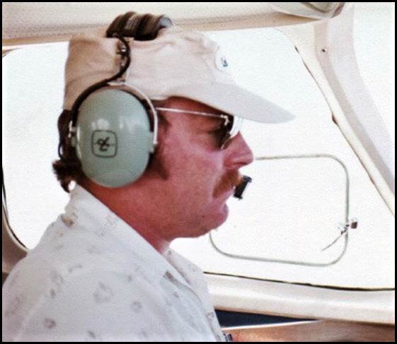
Jock
Head flying chartered Cessna 402 VH-BPX on Nat Map operations
in the early 1980s.
(XNatmap image from Bill Stuchbery)
Following
Terry Mulhollands departure from Nat Map in October 1988, Jock
acted as AUSLIGs Chief Pilot until mid-1991.
With Nat Map Jock flew over many areas of Australia; particularly
in outback areas. Later with the Australian Surveying and Land
Information Group, he also flew aerial photography operations
over the Pacific Island nations. Initially Jock flew over Vanuatu
in mid-1990 and he flew over the Kingdom of Tonga in June 1991.
Jock formally left AUSLIG on 11 March 1992 at age 45 years. At
the time his nominal position was Technical Officer, Level 1.
Jocks early retirement was made under redundancy provisions in
the Public Service Act. His retirement was promulgated on page
1340 of the Commonwealth of Australia Gazette, Issue PS 13, of
2 April 1992.
However, a farewell send-off function for Jock and fellow departing
Senior Technical Officer (Technical Officer, Level 4) John Ely
was held at the Ellery House office on Wednesday 19 February 1992.
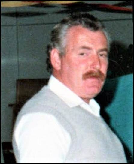
Jock
Head at Nat Maps Dandenong Office circa 1990.
(XNatmap image by Alan Scott)
After
leaving Nat Map Jock moved to Broken Hill with his wife and children.
Sadly while at Broken Hill Jock and his wife Betty went their
separate ways and he moved to Port Macquarie. Here Jock gave up
flying and undertook a course that qualified him to provide support
for people with disabilities. Jock found this field of work to
be very rewarding and made it his later-in-life vocation.
Unfortunately in September 2016, Jock was diagnosed with cancer.
Despite treatment, Jock succumbed to the disease on 14 August
2018. Jock was 71 years of age when he died. He was survived by
his former wife Betty and by their two children; son Dallas and
daughter Peita. Jock had requested there be no funeral service,
instead a private cremation of Jocks remains occurred on 21 August
2018.
On 25 November 2018 some 50 people attended a memorial service
for Jock at Port Macquaries Shelly Beach. Nat Map pilot Harry
Baker was one of the attendees. Jocks memorial service took place
at Harrys Lookout* where the Port Macquarie-Hastings Council
had installed a memorial seat with a plaque for Jock. The next
day, Jocks ashes were scattered nearby. The location of Harrys
Lookout is depicted in the satellite image below.
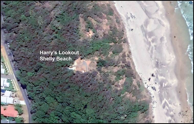
Location
of Harrys Lookout at Port Macquaries Shelly Beach.
(Google Earth image)
*Harrys
Lookout is named for Harry Thompson who in 1961 with Jean (his
wife) apparently drove from Warren in their Vanguard and caravan.
At this spot overlooking Shelly Beach where they both saw the
sea for the first time, their vehicle became bogged and so they
stopped there
for the rest of their lives. During that time they
raised their two children Neville and Robyn. The Thompsons became
local identities with Harry known as the mayor of Shelly Beach
and being named as one of Port Macquaries citizens of the year
in 1983.
An attempt by the Council to have them evicted as squatters had
to be abandoned because of community support for the Thompsons
and their voluntary role as caretakers of the beach over the years.
Jean died in 1985 and Harry died in 2000.
This
article is reproduced verbatim from the XNATMAP website
by permission of the author Laurie McLean.
https://www.xnatmap.org/viat/people/JMHead.htm
|